


Palma Sola Trace is located three miles from the Gulf of Mexico and just south of Tampa, Florida.
Emergency Management Info

There is a lot of information on this page to assist before, during and after an emergency situation. Please review prior to an event and be prepared.
*The Master and Villa Board of Directors encourage everyone to sign-up for the Bradenton and Manatee County emergency alert services.
Bradenton CodeRED
Manatee County Emergency Alert Program
>Emergency Notification Services Information
This area will provide updated information when an event occurs

>Manatee County Emergency Information
Get the latest weather updates here:

ABC News Channel 7 link
News Channel 8 Link
The Weather Channel
CNN StormTracker
New Interactive Map for Flood Zones
WHAT DO THE (X) FLOOD ZONES MEAN?
Palma Sola Trace is now in the X zone
- X (shaded) – Moderate risk area that does not typically require flood insurance. Also known as the 500 Year Flood Zone.
- X (no color) – Low risk area that does not typically require flood insurance.

PUBLICATIONS
Review this collection of publications to help you prepare for a disaster:
MAKE A DISASTER PLAN
Planning ahead for an emergency will help you and your loved ones stay safe and connected if a disaster occurs.
In addition to making a disaster plan, there are other ways you can prepare for an emergency:
- Sign up for Bradenton CodeRED alerts
- Manatee County Emergency Alert Program
- Build an emergency kit
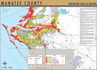
- Know your evacuation level
- Find nearby emergency shelters
- Sign up for the Special Needs Registry
(if you’ll need assistance in an evacuation)
FEMA Publications:
SANDBAG DISTRIBUTION LOCATION CLOSE TO PALMA SOLA TRACE
Please note that not all locations operate in every emergency.
Check this page to see which locations are open.
Do not underestimate the amount of work needed to fill ten bags and transport the sand bags back home.
Depending on how full you fill your bag, it can weigh 35-50 pounds. Ten bags can add 500 pounds to your vehicle.
G.T. Bray Park
5502 33rd Ave Dr W
Bradenton, FL 34209
Assistance:
Information is subject to change –
Contact Julie Conway – 941-758-9454 ext 107
for additional Palma Sola Trace Villas Information.
contact us.